Mingyong Glacier
Mingyong Glacier
A maritime glacier in northwest Yunnan, descending to 2,700 m altitude at the foot of Kawa Karpo, a sacred mountain in Tibetan Buddhism.
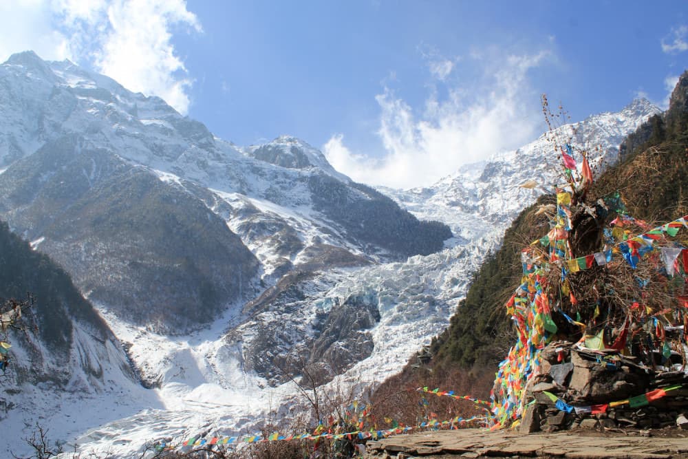
Mingyong Glacier is a monsoonal maritime glacier located on the eastern slopes of Meili's white mountain, one of eight sacred mountains in Tibetan Buddhism. It lies 12 km north of Feilai Si, in northwest Deqin County, Yunnan Province. Its glacier tongue descends to 2,700 meters altitude, making it the lowest-altitude and lowest-latitude glacier in all of Chine.
Why visit Mingyong Glacier
The site combines three rarely-found interests: a glacier accessible on foot from an inhabited village, a living sanctuary of Tibetan Buddhism (Mount Kawa Karpo remains one of Tibet's eight sacred mountains), and a direct witness to climate change. The glacier has retreated roughly 200 meters in four years and 2.7 km over several decades, making it a prime observation point for understanding the evolution of glaciers in the eastern Himalaya.
The trail between the Tibetan village of Mingyong and Taizi Temple remains one of Yunnan's rare walking routes allowing close approach to a glacier front on foot, within an actively practiced cultural setting.
History and sacred context
The glacier is formed by the runoff from Mount Kawa Karpo, the main peak of the Meili massif. Meili's snows feed it at approximately 232 million cubic meters annually. For Tibetan Buddhists, Kawa Karpo is not a summit to conquer: it is one of eight sacred mountains and has never been successfully climbed. A 1991 Sino-Japanese expedition ended in the disappearance of seventeen climbers, after which local authorities banned all climbing attempts at the request of Tibetan communities.
Each autumn, pilgrims perform the kora, a ritual circumambulation around the massif, of which Mingyong Glacier forms one of the lower stages.
What to see on site
The glacier and its glacier tongue
The glacier tongue winds 11.7 km long and approximately 3 km wide down into the Lantsang River (Mekong) valley. The massif contains 3 peaks above 6,000 m and 5 peaks above 5,000 m. In winter, the glacier tongue stretches from 2,800 m to 5,500 m altitude. The contrast between ice and the coniferous and deciduous forests surrounding it makes the site distinctive—unusual for a glacier at this latitude in Asia.
Taizi Temple
At the mountain's base, Taizi Temple is a small shrine devoted to Meili Mountain. Buddhist pilgrims burn incense there and pray facing Mount Kawa Karpo, whose view from the esplanade remains one of the walk's highlights.
Lotus Flower Temple
More modest, Lotus Flower Temple also marks the trail and exemplifies the interweaving of glacial landscape and Tibetan religious practice.
Mingyong village
Some 8 km at the glacier's foot, the Tibetan village of Mingyong (about fifty households) subsists partly on horse herding and welcoming hikers. Traditional Tibetan houses, prayer flags and water mills offer a glimpse into daily life in Yunnan's high country.
When to go
Two seasons stand out:
- Winter (December–February): the glacier tongue reaches maximum extension and skies are often clear, but temperatures are sharp and altitude is more keenly felt.
- Spring and autumn (April–May, September–October): the most comfortable hiking conditions, generally clear skies in autumn, peak pilgrimage season.
- Summer (June–August): monsoon season, frequent mists often obscuring Kawa Karpo.
Practical information
- Duration: allow 4 to 6 hours round-trip from Mingyong village to Taizi Temple (approximately 2 hours uphill).
- Two trails are maintained: one for hiking, one for horseback riding (horses rented in the village).
- Fees: site entrance and horse rental payable on-site, modest prices but variable — check with your accommodation in Deqin.
- Altitude: departure at approximately 2,200 m, arrival around 2,700–2,900 m. One day of acclimatization in Deqin (3,400 m) or Shangri-La (3,200 m) is recommended.
- Equipment: hiking boots, warm clothing year-round, sun protection (glare from ice).
How to get there
From Deqin's coach station, daily buses serve Mingyong village in the morning. The route runs along the Mekong valley for approximately 2 hours. For a group or more flexible itinerary, renting a minivan with driver is the most practical option, especially to combine a glacier visit with a sunrise stop at Feilai Si.
Nearby
Mingyong Glacier is typically visited as part of a stay in Deqin, gateway to the Meili massif. The region extends to other Tibetan sites in Yunnan and eastern Tibet, such as the Gyantsé Dzong. Further south, in the Dali region, the Cangshan massif offers another face of Yunnan's mountains.
Frequently asked questions
Plan your trip
Mingyong Glacier logically fits into an itinerary connecting Lijiang, Shangri-La and Deqin, on the route through northwest Yunnan. To build a complete itinerary including this Tibetan region, see our suggestions for travel in Chine.
Interested in this visit?
We can include it in your personalised itinerary.